Step 1
Roots Snapshot
A quick first look. For anyone starting from a family name and a town, village or prefecture.
Download this sample as delivered (PDF, 0.6 MB)
Roots Snapshot
The Ando families of Nagaiwaya 長岩屋の安東一族
Where the Ando name is found, and the village of Nagaiwaya in brief
| Registered domicile (honseki) | Nagaiwaya, Bungo-Takada City, Oita Prefecture |
|---|---|
| Prepared for | [client name withheld] |
| Date | October 5, 2026 |
Sample. The family name and registered domicile are fictional; the places, records and research are real.
綴Koseki Roots
At a glance
- Your family's registered domicile (honseki) is Nagaiwaya, a valley in the Kunisaki Peninsula, Oita Prefecture.
- Oita has more people named Ando (安東) than any other prefecture, about 4,600.
- The village temple is Tennenji, about 0.6 km (0.4 mi) from the registered domicile.
- At Sano, about 9 km (6 mi) away, an Ando fought in 1580 for the Ōtomo, the warlords who ruled Bungo. An Ando family there served as village headmen in the Edo period (1603–1868).
- This Snapshot covers the surname and its village; it does not prove your own line. Your koseki traces your line back to the 1870s–80s; the link to these older families usually rests on where the name is found, so our charts draw it as a dotted line.
Where the Ando name is found
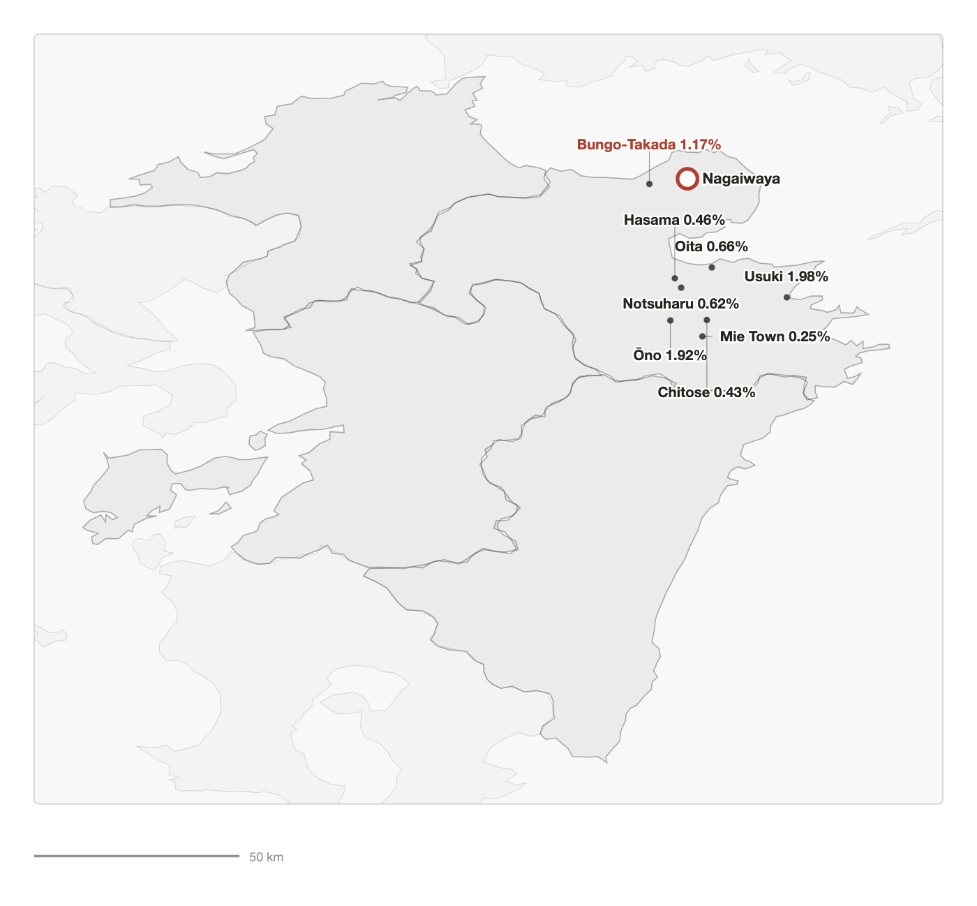
About 16,700 people in Japan bear the surname Ando (安東). Oita Prefecture has the most of any prefecture, about 4,600. Some 300 live in Bungo-Takada City, and Ando families still live in the Tomiku valley, where Nagaiwaya lies. Within the prefecture the name is densest in Usuki City and Ōno Town in the south. Bungo-Takada City, about 9 km (6 mi) in a straight line from the ancestral village, comes next.
| Town | Households | Share | From the village |
|---|---|---|---|
| Usuki City | 192 | 1.98% | ~55 km (~34 mi) |
| Ōno Town, Ōno District | 34 | 1.92% | ~60 km (~37 mi) |
| Bungo-Takada City | 60 | 1.17% | ~9 km (~6 mi) |
| Oita City | 512 | 0.66% | ~38 km (~24 mi) |
| Notsuharu Town, Oita District | 9 | 0.62% | ~46 km (~29 mi) |
| Hasama Town, Oita District | 15 | 0.46% | ~42 km (~26 mi) |
The place called Nagaiwaya
Nagaiwaya is a valley in the center of the Kunisaki Peninsula in Oita Prefecture, on the upper reaches of the Tomiku River, which flows west from Mount Futago. The local gazetteer Nishi-Kunisaki Gunshi (a local encyclopedia of the district, compiled 1923) describes it as a gorge about 4 km (2.5 mi) long lined with sheer cliffs hundreds of feet high. The gorge was once known as "Tomiku-yaba" (yaba: a gorge of towering rock formations). A land register of Bungo Province from 1285 lists the Tomiku estate (shōen, a medieval landholding worked by local families), including Nagaiwaya, as a holding of Usa Mirokuji, the Buddhist temple attached to the great Usa Shrine. The estate covered seventy chō of fields (about 70 hectares, or 170 acres).
In the Edo period (1603–1868) the area belonged to the Shimabara domain (the Matsudaira clan), one of some 260 domains ruled by hereditary lords under the shogun (Japan's military ruler). Shimabara's castle was in today's Nagasaki Prefecture, and this corner of Kunisaki was one of its detached holdings. In 1875 ten villages of the old estate were combined as Tomiku Village. In 1889 it became an area within Nishi-Tomiku Village, in 1951 part of Takada Town, and in 1954 part of Bungo-Takada City.
The village temples and festivals
The village temple is Tennenji (mountain name Nagaiwaya-san; the ending -ji means "temple"), a Tendai temple about 0.6 km (0.4 mi) from the registered domicile (honseki). It is counted among the temples of Rokugō Manzan, a network of Tendai Buddhist mountain temples unique to the Kunisaki Peninsula and recorded since the 8th century. Tendai is one of Japan's major Buddhist schools. Tennenji's New Year fire festival, the Shujō Onie, with dancers dressed as demons, was designated an Important Intangible Folk Cultural Property of Japan in 1977, as part of the Kunisaki Shujō Onie. About 0.9 km (0.6 mi) away stands Chōanji (Kongō-san), also of the Tendai sect.
The families of the name, in one paragraph
This paragraph is about the families of the name, not yet about your own line. The Ando of Nagaiwaya made their home in the Tomiku valley, a place recorded since the Kamakura period (1185–1333), whose temple Tennenji belongs to Rokugō Manzan. In the Warring States period (Sengoku, c. 1467–1600), a man of the same surname fought on the side of the Ōtomo, the warlords who ruled Bungo, at the Battle of Kurakake Castle (1580) at Sano, about 9 km (6 mi) away.
Through the Edo period an Ando family is also recorded as village headmen (hereditary local officials) at Sano. The Ando of Nagaiwaya may connect to one or more of these lines. The koseki reaches back only to the 1870s–80s; before that, temple records may help, if they survive.
Background in brief
Ages. Old records give ages in "counted years": one at birth and another every New Year. We give Western years everywhere and note the original where it matters; dates follow the note at the top of this Snapshot.
The records. From 1886 onward, the koseki records every birth, marriage, adoption and death in a household — but registers before that date are sealed by law. For the time before that we turn to sources from the Edo period. These are the temple's death register and memorial tablets, the village's religious census, the domain's land surveys, and, for a few families, letters and land deeds handed down for centuries. Local histories compiled in the 1910s–30s (the "gazetteers" we cite) collected many of these. A Roots Report tells you which of them exist for your village; a Family Chronicle (our book-length family history) works through what they say. They record the families of the name in the village; whether they are your own ancestors can seldom be shown.
The emigration years. Government-sponsored emigration to Hawaii began in 1885, mostly from Hiroshima, Yamaguchi, Kumamoto, Fukuoka and later Okinawa. The mainland US and Canada followed in the 1890s, Brazil from 1908. Emigrants stayed on their village register. That is why the koseki of a family that left in 1905 still sits in a city office in Japan, and why its registered domicile (honseki) is the key to everything.
Terms used
- Kamakura period (1185–1333)
- The first warrior government; land registers and estate records begin naming local families.
- Warring States period (Sengoku, c. 1467–1600)
- Central power collapses and regional warlords fight for territory; local land-holding families fight for them in return for land.
- Edo period (1603–1868)
- Two and a half centuries of peace under the Tokugawa shoguns. Villages are taxed in rice and run by hereditary headmen.
- Domain (han)
- One of about 260 fiefs ruled by hereditary lords (daimyo) under the shogun. A village "belonged" to a domain, which taxed it.
- Village headman (shōya)
- The hereditary local official who ran a village for the domain: taxes, disputes, records. The post went to a leading farming family of the village.
- Ōtomo clan
- The warlords who ruled Bungo (today's Oita) and much of northern Kyushu (Japan's southwestern main island) for 400 years until 1593.
- Estate (shōen) · chō
- A medieval landholding owned by a temple, shrine or noble family. 1 chō ≈ 1 hectare (2.5 acres).
- Gazetteer
- A local encyclopedia of a district or prefecture, compiled from older documents and local tradition.
More in our glossary.
About the Roots Snapshot
This Snapshot summarizes what published records alone show, before any koseki is examined. The Roots Report takes it much further. It maps the surname down to the hamlet, names the likely family temples, and searches records of the name from the Edo-period village back to the medieval and Warring States periods.
Get a Snapshot for your name and village — $29
All we need is your ancestor's surname and town or village. If you know only the prefecture, we can still begin; for common surnames, this may not narrow down to one town.